
EADA10 Online Practice Questions and Answers
An ArcGIS user is required to create a new feature class output of rivers of California Currently, the user has a feature class of the USA rivers and a feature class of the California state boundary.
Which process would generate the necessary output?
A. Union tool with the USA rivers and California state boundary selected for input features
B. Clip tool with the USA rivers as input features and California state boundary as clip features
C. Union tool with the USA rivers as input and California state boundary as output feature class
D. Clip tool with the California state boundary as input features and USA rivers as clip features 100% Real QandAs | 100% Real Pass
The ArcGIS user works with a map document that contains a very detailed image that takes several seconds to draw when panning.
Which action can the ArcGIS user take that will improve the performance when panning in ArcMap?
A. put the image layer in a group laver
B. set the reference scale on the image layer
C. put the image laver in a basemap layer
D. make the image layer selectable
An ArcGIS user wants to share layer and attribute information in a map document with a colleague who does NOT have ArcGIS Desktop
The ArcGIS user must export in which format in order for the colleague to view the information?
A. PDF
B. SVG
C. PNG
D. BMP
What can cause bitmapped, banded, or low-quality display printed maps?
A. high output resolution
B. High Output Image Quality (OIQ)
C. transparent symbology
D. TrueType fonts
An ArcGIS user has a feature class of utility poles and a feature class containing transformers. If a utility pole is deleted the ArcGIS user wants all of its associated transformers to be deleted as well.
Which type of association will allow the ArcGIS user to accomplish this task?
100% Real QandAs | 100% Real Pass
A. join
B. spatial join
C. relate
D. relationship class
Which two methods are valid for calculating the values of a field using a calculation expression? (Choose two)
A. If more than one field is selected, the calculation can be applied to each field.
B. For VB calculations, field names must be enclosed in square brackets [ ]
C. If any records are currently selected in the table, only the selected records will be calculated
D. For Python calculations, field names must be enclosed in double quotes" "
Table A shows the attribute table for a point feature class containing values for well type (Type) and well diameter (Diameter). This portion of the table shows all the possible combinations for these values in the geodatabase.
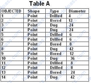
Using the well type to define the subtypes, how should the ArcGIS user structure the subtypes and domains in the geodatabase to help with data automation and database design? 100% Real QandAs | 100% Real Pass
100% Real QandAs | 100% Real Pass
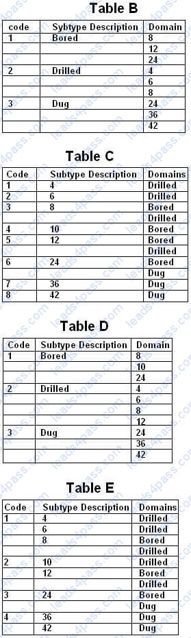
Table A shows the attribute table for a point feature class containing values for well type (Type) and well diameter (Diameter). This portion shows all the possible combinations for these values in the geodatabase.
Using the well type to define the subtypes, how should the ArcGIS user structure the subtypes and domains in the geodatabase to help with data automation and database design?
A. Table B
B. Table C
C. Table D D. Table E
An ArcGIS user is identifying specific study areas to display in ArcMap that can be saved to an mxd file. Which functionality in ArcMap allows the creation of the study area views?
A. Generate Overlay
B. Create Bookmarks
C. Generate XY Area
D. Create Area Overlay
In ArcCatalog, how can an ArcGIS user repair an .mxd file that has broken data sources?
A. use the MXD Doctor utility
B. right-click .mxd file and use the Set Data Sources tool
C. right-click .mxd file and update Map Properties
D. use the Repair Data Sources geoprocessing tool
An ArcGIS user is working on a map of a province. The user wants to create an inset to identify the province within the entire country.
Which map element should the user employ?
A. Extent rectangle
B. Data Driven Pages
C. Reference scale
D. New graphics layer





All rights are reserved by
leads4pass.com. Any changes, copy or trademarks abuse will be
regarded as infringement.
leads4pass.com will reserve the right to pursue accountability.
Copyright © 2004-
2026 leads4pass.com.